
Main contractors
PAS 128 surveys before you break ground. CCTV and as-builts at handover.
BAM · Kier · Skanska · Morgan Sindall
PAS 128 utility mapping, CCTV drainage surveys, topographical and measured building surveys, 3D laser scanning, jetting and no-dig repairs. One accredited team, mobilised from Gloucestershire to sites across the UK.
Accredited & approved


Move the lens to see what's under the street. Finding it before you dig is our job.


PAS 128 surveys before you break ground. CCTV and as-builts at handover.
BAM · Kier · Skanska · Morgan Sindall
Topos for layouts, Section 104 adoption surveys and a clean, jetted system at handover.
Persimmon · Taylor Wimpey · Barratt · Redrow
Topo, utility and point-cloud data your design can stand on.
Hydrock · Curtins · BWB Consulting
Drainage maintenance, measured surveys and careful work in historic buildings.
Gloucestershire County Council · National Trust
Services
Most projects need three or four specialists before work can start. We cover the lot, so you get one mobilisation, one set of RAMS, one point of contact and data that fits together first time.
01
We start where most surveys stop. Find it, map it, inspect it and fix it, before it costs you a programme.

From QL-D desktop searches to QL-A trial-hole verification. Electromagnetic and radar detection, with every service, depth and position on one clear drawing.

Coded surveys for Section 104 adoption, build-overs, handovers and defect investigation. Major defects reported on the day; the full report follows in days.

Patch repairs and full-length CIPP liners for 70–560 mm pipes, WRc-approved with a 50-year projected life. Laterals reinstated precisely. No digging, no disruption.

Van packs to combination units. Blockages, pre-survey cleans, interceptors and septic tanks, plus vacuum excavation to dig safely around live services.
Also below ground Ground investigation · Confined-space and culvert inspection · Desktop utility searches · Percolation test support
02
Levels and features captured once, accurately, and delivered in the format your designers already use.

Total stations and GNSS capture levels, features and boundaries, from open fields to live highways and railways. 2D or 3D, in DWG, DXF or PDF.
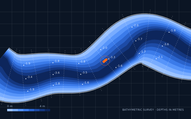 Hydrographic
Riverbed, lake and channel surveys by an RYA-qualified team, most recently on the River Aire near Goole, giving schemes accurate underwater levels.
Also on the ground As-built and adoption surveys · Engineering surveys · UAV and drone mapping · Highways and rail
03
Buildings and structures measured precisely, ready for design, refurbishment, asset management or BIM.

Floor plans, elevations and sections drawn on an accurately surveyed footprint. Every level layered and every drawing checked before it leaves us.

Point clouds controlled by total station and GNSS, modelled in Revit so you can walk through, slice and measure, right down to sockets and cable runs.
Also above ground UAV and drone surveys · Structural monitoring · Dilapidation surveys · Surveys for BIM

Tunnels · culverts · theatres · live railways
If it can be measured, we'll measure it.
Why Solum
The ground is where projects go wrong. Since 2013 we've made sure it doesn't, for tier-one contractors, national housebuilders, consultants and councils.
Utility, drainage, topographical and scanning crews under one project lead. One programme, one set of RAMS, one invoice.
One team captures it all, so your topo, utilities and drainage line up on one drawing. No stitching together other people's files.
Major defects are flagged on the day, often on site. Reports, marked-up drawings and costed remedials follow within days.
Laser scanners, Leica and Trimble instruments, EML and GPR, crawler CCTV, an Elios 3 confined-space drone and Euro 6 combination units.
MSCC5 and OS19x-trained report writers, City & Guilds jetting operatives and CICES-qualified surveyors, in an RICS-regulated firm.
Every drawing is checked before it's sent. You won't pay for repairs you don't need, or miss the ones you do.
Projects
A few recent jobs. Every one of them started with a phone call. Follow our latest work on LinkedIn
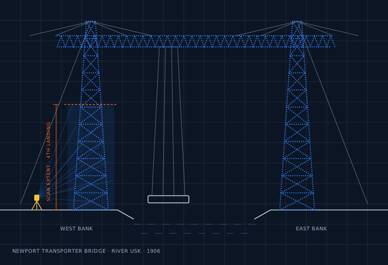
Newport · South Wales
CCTV, utility and topographical surveys to the visitor centre, highway and car parks, plus laser scanning of the bridge's two west bank towers up to the fourth landing.

Bristol
Laser scanning inside Frank Matcham's 1912 theatre, capturing the auditorium and front-of-house in full 3D.

Penzance · Cornwall
A complete point cloud of the station, ready for design teams to measure, model and plan from.

Bath · Somerset
Night-shift laser scanning on the platforms of Brunel's 1840 station.

Devon & beyond
Crawlers, floats, array GPR, EML, laser scanning, total stations and GNSS on a collapsed Devon culvert, and our Elios 3 LiDAR drone mapping a 10 m wall collapse.
How it works
A survey traverse runs station to station. So does every job we take on: no guesswork in between.
STN 01
A postcode, a red-line plan or a drawing is enough to start. We'll ask what the data is for, so we scope it right.
STN 02
The right survey specification or PAS 128 quality level, a programme and a price. No padding, no surprises.
STN 03
An accredited crew arrives with the right kit and approved RAMS. Anything urgent is flagged on the day.
STN 04
Drawings, reports and models in the formats your team already uses: DWG, DXF, PDF, Revit or point cloud.
What lands in your inbox


The team
Solum was founded in Berkeley, Gloucestershire, in 2013. Today our crews and fleet work the length of the country, led by a management team with decades of combined surveying and construction experience, and a straight answer when you need one.
Director
Associate Director, Utility Surveys
Associate Director, Topographical & Measured Building Surveys
Finance Director
What we stand for
Surveyor looking for your next move? See what we're working on
FAQs
Can't see yours? Call the office on 01454 413592 and talk to a surveyor.
Most sites start with QL-D (a desktop search of utility records) plus QL-B (a detection survey using electromagnetic locators and ground-penetrating radar). Together they give you the most useful picture quickly. QL-C adds a site reconnaissance of surface features, and QL-A confirms selected services by exposing them, usually on congested sites or where an asset owner requires it. Not sure? Tell us what you're planning and we'll recommend the right level.
Yes. We're based in Berkeley, Gloucestershire, and work on sites right across the UK, from Cornwall to Yorkshire.
Major defects are reported the same day, often on site, so a repair and re-survey can happen straight away. The full report, with marked-up drawings, coded footage and costed remedials, follows electronically within a couple of days.
Yes. We recommend jetting lines before a CCTV survey so defects aren't hidden under debris. Where defects are found, our no-dig patch and CIPP lining systems repair pipes from 70 to 560 mm without excavation.
Whatever your team works in: DWG and DXF for CAD, PDF and paper for site, 2D or 3D, registered point clouds and Revit models for BIM.
We're an RICS-regulated firm and CICES members, with Constructionline Gold, CHAS Premium Plus, SafeContractor and Cyber Essentials Plus accreditation. Our report writers are trained to MSCC5 and OS19x, our jetting operatives hold City & Guilds certificates, and we're a licensed waste carrier (CBDU239180).
Yes, for small trenches around congested services. Our combination units break up the ground with high-pressure water and vacuum the spoil away, so no blade goes near live services. Larger areas can be arranged through trusted partners.
Yes. We produce measured building surveys and 3D laser scans of everything from schools and offices to theatres and railway stations, and can model them in Revit for BIM.
Get a quote
Send a postcode and a few details and we'll come back with a clear, competitive quote. Prefer to talk it through? Call the office.
01454 413592


Also: Cyber Essentials Plus · Licensed waste carrier CBDU239180
We'll review your site details and come back to you shortly. If it's urgent, call 01454 413592.